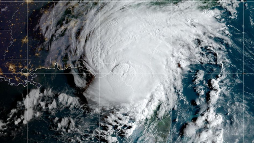
Iran Press/ America: Idalia moved ashore on Wednesday morning near Keaton Beach in the Big Bend area – where the panhandle meets the peninsula – with maximum sustained winds of 125 mph and has begun an ominous trudge across Florida and the coasts of Georgia and South Carolina, where residents are urged to beware the sort of floods, strong winds and tornadoes already impacting Florida’s west coast, the National Hurricane Center said.
It is the third hurricane to make landfall in Florida in the last 12 months, following Ian last September and Nicole in October, CNN reported.
Residents had been urged to flee and the National Guard prepped for rescues as "extremely dangerous" Idalia took aim with once-in-a-lifetime damaging winds and a life-threatening storm surge of up to 16 feet, the National Hurricane Center said.
“There is great potential for death and catastrophic devastation,” warned the Taylor County Sheriff’s Office, in the Big Bend region southeast of Tallahassee.
A rare extreme wind warning – issued in cases of life-threatening sustained winds of 115 mph or more – was issued for parts of the Big Bend region – including Dixie and Taylor counties, even as Idalia’s sustained winds slowed slightly around 7 a.m. from Category 4 strength.
“Treat these imminent extreme winds as if a tornado was approaching and move immediately to the safe room in your shelter,” the National Weather Service office in Tallahassee warned, adding: “Take action now to protect your life!”
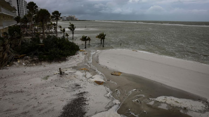
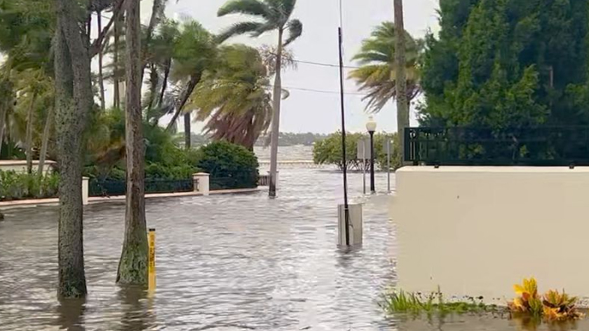
A tornado watch also is in place for nearly 12 million people across central and northern Florida and southeast Georgia until 3 p.m., Wednesday, as conditions continue to deteriorate, with coastal streets and lots flooding in places including Tampa, St. Petersburg and Fort Myers Beach as ocean water pushes ashore, rain pours down and winds whip.
Destruction is possible far behind the forecast cone, Florida Governor, Ron DeSantis, said on Wednesday morning. At least 11 tornado warnings had already been issued – even in places “way outside the cone that you see on your TV screens,” he said.
As its eye moves onshore in the Big Bend region, Idalia’s core will bring destructive winds and storm surge high enough to stack a wall of seawater halfway up the second floor of an average building. It could be the first major hurricane at Category 3 or stronger to hit the area.
“This has the makings of an unprecedented event for this part of the state,” the National Weather Service in Tallahassee said. “There are NO major hurricanes in the historical dataset going back to 1851 that have tracked into Apalachee Bay. None."
“Don’t mess around with this one.”
DeSantis warned of “significant, significant impact” to the Big Bend region, saying first responders will not be able to reach the few people who have stayed in evacuation zones until after the storm passes.
Do not try to “‘ride’ this one out,” police told residents in the Big Bend city of Perry, adding storm surge higher than 15 feet is “not survivable if you are caught in it.” Storm surge accounts for nearly half of all hurricane-related fatalities, the National Oceanic and Atmospheric Administration says.
In Tampa, well south of the projected landfall zone, Idalia’s storm surge began to flood streets Tuesday within a half-hour, Police Chief Lee Bercaw said.
“I witnessed for myself people driving in the water,” he said at a storm briefing Tuesday. “Don’t be that person. Remember: Turn around, don’t drown.”
Storm surge could cut off Cedar Key, on the southern side of the Big Bend, National Hurricane Center Deputy Director Jamie Rhome said.
Danger to life
Most of Florida's 21 million residents, and many in the adjacent states of Georgia and South Carolina, were under hurricane warnings and other storm-related advisories. State emergency declarations were issued in all three.
Florida's Gulf Coast, southeastern Georgia and eastern parts of North and South Carolina could face 4 to 8 inches (10 to 20 cm) of rain through Thursday, with isolated areas seeing as much as a foot of rain (30 cm), the hurricane center warned.
Officials said the storm's most dangerous feature would be a powerful surge of wind-driven surf that is expected to flood barrier islands and other low-lying areas along the coast.
After hitting Florida, Idalia’s center is forecast to move near or along the coasts of Georgia, South Carolina and North Carolina late Wednesday and Thursday, the hurricane center said.
“Idalia is likely to still be a hurricane while moving across southern Georgia, and possibly when it reaches the coast of Georgia or southern South Carolina late today,” the hurricane center said Wednesday morning.
North Carolina and Georgia have also declared states of emergency as they prepare for floods and hurricane force winds.
224
Read More:
Hurricane Hilary threatens Mexico, California with 'catastrophic floods'
Maryam Abolbagha
